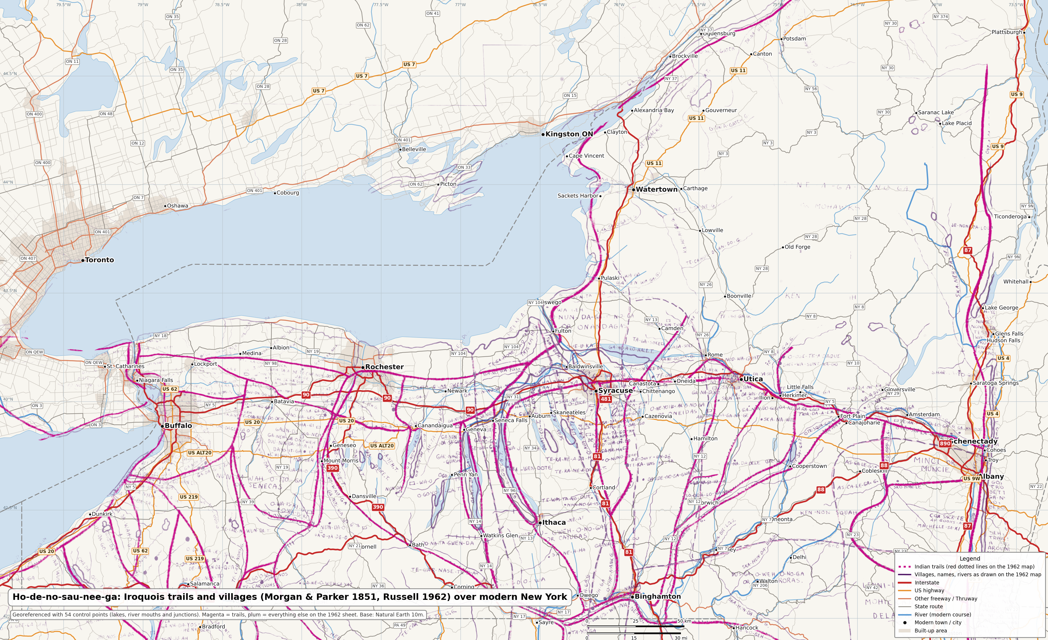
Map of Ho-de-no-sau-nee-ga, or the People of the Long House (Morgan & Parker 1851, redrawn by Russell 1962)
Lewis Henry Morgan and Ely S. Parker's 1851 map of the Haudenosaunee homeland, showing the principal trails, villages, lakes and rivers with their Iroquois names, in Eber L. Russell's 1962 redraw with villages, trails and springs added from fifty years of research. Rubber-sheeted to modern lakes and river junctions.
Source
| Map | Map of Ho-De-No-Sau-Nee-Ga or the People of the Long House |
|---|---|
| Author | Lewis H. Morgan and Ely S. Parker, 1851 — redrawn by Eber L. Russell, Perrysburg, N.Y., 1962 |
| Archive | Norman B. Leventhal Map & Education Center, Boston Public Library · 1:590,000 (1962 sheet) |
| Rights | Public domain. The 1851 original is public domain. The 1962 redraw was registered (Eber L. Russell, 28 Jan 1963, reg. F34020, CCE Third Series v17 pt 6) but no renewal appears in the Copyright Office public records (renewals 1978+ all searchable; deadline was 31 Dec 1991), so it entered the public domain on 1 Jan 1992. Renewal search completed 2026-09-17. Evidence |
| Accuracy | About 5 km (RMS 5.7 km at 54 control points). The 1962 drawing is loose: the scale wanders between about 11 and 16 px/km across the sheet and some village dots sit 10–15 km from their historic sites. Read the overlay as which valley, not which side of the road. |
| Method | Thin-plate spline rubber sheet pinned to lake tips, river mouths and junctions; weighted control points. See the methodology. |
| Version | 1.0.0, updated 2026-09-17 |
| Covers | New York |
Downloads
- Google Earth overlay (KMZ) — free (2.2 MB)
- GeoTIFF, tinted trails, EPSG:4326 (QGIS, ArcGIS) — free (5 MB)
- Statewide sheet over the modern map (3600 × 2200 PNG) — free (5.2 MB)
Changelog
- 1.0.0 (2026-09-17): First release: 54 control points, tinted and scan layers, z5–z12.
Control points
The full list of control points with residuals is in control-points.geojson. Historic names indexed for search: names.geojson.